Birding at serra de cadi - coll de pal
Serra de Cadi - Coll de Pal
Attraction
Another Pyrenean high mountain area with the promise of Alpine Accentor, Rock Thrush and Wallcreeper at higher altitudes, Citril Finch around the treeline, Black Woodpecker and even Tengmalm’s Owl in the forests, raptors including Lammergeier and Golden Eagle overhead and Red-backed Shrike and buntings lower down. There is a road to the Coll de Pal which allows you to explore all these habitats without too much walking. In June 2018 I failed to find many of the key species, partly because rain and mist made it impossible to scan for raptors but the notes below describe what I did find.
Getting there
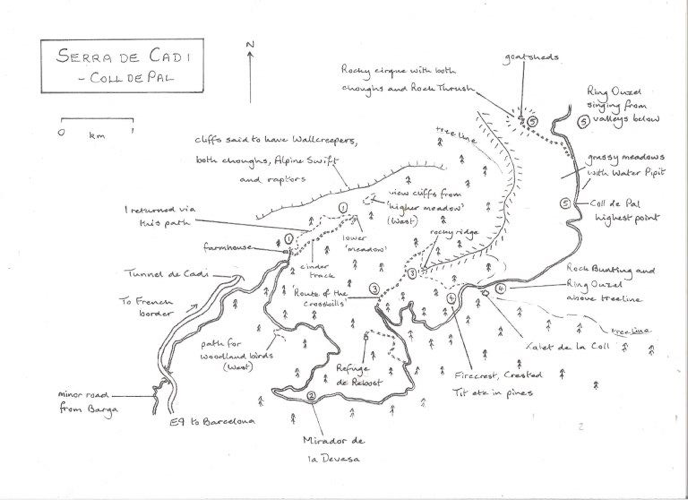
The Coll de Pal is immediately east of the Tunnel de Cadi through which the E9 (C16) connects Puigcerda at the French border with Barcelona via Manresa. To get to the Coll de Pal road you have to turn off into the village of Barga, 6 km south of the tunnel and find a minor road (42.2541N, 1.8611E) heading north from the village, signposted to Coll de Pal
Notes
1. Steve West recommends a walk from a large stone farmhouse on the left, after passing the km 6 marker. He describes walking up beside a stream to some meadows after 1.5 km with birds such as Tree Pipit, Red-backed Shrike and 3 buntings, Rock, Cirl and Ortolan. From there you can apparently scan some cliffs for ‘Lammergeier, Griffon Vulture, Golden Eagle, Peregrine, Red-billed Chough, Alpine Chough, Alpine Swift, Crag Martin and even Wallcreeper.’ I parked by the road (42.2971, 1.8715E), walked up to the farmhouse then doubled back a little to find a cinder track which ran parallel with the stream. There were Grey Wagtails on the stream but the woodland had mostly common UK species apart from Bonelli’s Warbler and Firecrest. After 1.1 km, just before the track bent right, there was an open area on the left (42.3029N, 1.8831E), more a grassy patch than a meadow. I turned left into this open area and tried to find a path to a bigger meadow but the only path I found took me back to the farmhouse at a higher level than before, through scrubbier habitat. Birds here included Stonechat, Dunnock, Firecrest, Crested Tit, more Bonelli’s Warblers and a Subalpine Warbler. A bunting called but I couldn’t tell whether it was Rock or Cirl. I didn’t find anywhere to scan across to the cliffs and the persistent mists meant there was little chance of seeing raptors. Even so, I would have heard choughs if they’d been anywhere near and Black Woodpeckers if they’d called. Looking on historical images on Google Earth it looks like I should have aimed for the right-hand corner of the first ‘meadow’ and scrambled upwards to a higher ‘meadow’ but the vegetation has now grown so there was no obvious way of doing that. Hence I missed out on the cliff species, the shrikes, pipits and most of the buntings – some of which may have gone as the habitat seems to have changed.
2. At km 11 there’s a viewpoint, the Mirador de la Devesa (42.2792N, 1.8766E). On a better day, this should be a good place to scan for raptors. The best birds I had were Rock Bunting, Red-billed Chough, Black Redstart and Bonelli’s Warbler.
3. After the turning to Refuge de Rebost and just after km 14 there’s a track to the left where the road bends right. This track (42.2914N, 1.8867E) is named the Route of the Crossbills (Ruta des Trencapinyes) and leads through coniferous forest to the Mirador del Ornis. I didn’t get crossbills but did find Citril Finch near the beginning of the track and Crested Tits in the wood. I didn’t go as far as the mirador but the surrounding hills have steep cliffs so should be great for raptors at least on a clear day. It also doubles back to the main road via a rocky ridge that might be worth checking in better weather.
4. The Xalet de la Coll (42.2931N, 1.9060E) at km 17 is on the treeline. The 1 km above the Xalet is open with scattered trees and so should have been the perfect area for Citril Finch but the best birds I found were Rock Bunting, Woodlark and Ring Ouzel. Dunnock and Mistle Thrush were other birds typical of this habitat. I also walked the wooded 1 km below the Xalet but Firecrest and Crested Tit were the only birds apart from common UK species.
5. The Coll itself (42.3039N, 1.9225E) is at the 19 km mark, the highest part of the road at 2109 metres. It’s an area of rolling grassland and scattered rocks where Wheatear is the commonest bird alongside a few Water Pipits, Pied Wagtails and Skylarks. Ring Ouzels sang in the valleys below. To find rockier habitat I walked left near km 20 along a track signposted to Pleta da Combabella. It leads to a goatshed (42.3160N, 1.9124E) at the base of a rocky cirque which had about 12 pairs of Red-billed Chough, 2-3 pairs of Alpine Chough, a pair of Kestrels and, in addition to Wheatears, Skylarks, Water Pipits, Black Redstart and Marmots, a singing male Rock Thrush. This looked like the only potential Alpine Accentor habitat around the Coll.
I also added Cirl Bunting and Iberian Green Woodpecker at the bottom of the road, near Barga. So, apart from raptors, which would have been difficult in that weather, the birds that I didn’t find were Tree Pipit, Red-backed Shrike and Ortolan Bunting lower down, Marsh Tit, Bullfinch, Wryneck and Black Woodpecker in the woods, Alpine Swift and Crag Martin overhead and Alpine Accentor and Wallcreeper in the highest rocks. Black Woodpecker is the symbol of the National Park and is said to be ‘common’ so, even in that weather, I was surprised not to at least hear one.